Arouca Geopark: Travel Guide to Discover the Main Trails and Attractions

last update: 29/03/2025

Arouca Geopark: The Complete Visit Guide to Explore Trails, Attractions and Geosites [2025] with Map

With an incredible extension of 328 km2 and created in 2009, this geopark included in the UNESCO network was the second to exist in Portugal. 41 geosites of enormous interest are mapped for their rich geological heritage, including Ichnofossils, Breeding Stones and giant Trilobites. The geopark also includes basic sites such as the Paiva Walkways, the Arouca Monastery or the Trilobites Museum.

Where to stay during your visit to the Geopark?

The beginning of the vast territory of the Arouca Geopark is just a few km from Cimo da Vinha – Nature Spot, so this visit could be a unique opportunity to stay the night with us – in one of our Suites, Canastro or Glamping Tents – and visit more deeply the beautiful municipality of Arouca.

Main Attractions of Arouca Geopark

Arouca Geopark is full of natural and cultural attractions that delight visitors. The Historic Center of Arouca offers a stroll through the town’s picturesque streets, where historical monuments such as the Arouca Monastery and the Sacred Art Museum stand out. In Serra da Freita, visitors can explore stunning routes and admire a unique landscape of mountains, valleys and unique rock formations. The Arda Valley, with its lush vegetation and serene landscapes, is perfect for those looking for tranquility in the middle of nature. the Paiva valley is famous for the Paiva Walkways, one of the most impressive attractions in Portugal, where you can walk along the river and enjoy dizzying views. Finally, the Mining Region, with its remains of old mines dating back to World War II, offers a fascinating look at the geological and industrial history of the region, completing the vast set of experiences that make Arouca Geopark an unmissable destination.

Frecha da Mizarela
© photo by VidaAtiva.pt

All 41 Geosites

♦ 1 Panoramic view of Detrelo da Malhada (viewpoint)

♦ 2 Côto do Boi

♦ 3 São Pedro Velho (granite dome)

♦ 4 Marmitas de Gigante do Caima

♦ 5 Mizarela Lithological Contact

♦ 6 Frecha da Mizarela (highest waterfall in mainland Portugal)

♦ 7 Birth Stones

♦ 8 Campo de Dobras da Castanheira

♦ 9 Cabaços Quartz Lode

♦ 10 Panoramic view of the Castanheira Coast

♦ 11 Bora Stones of Junqueiro

♦ 12 Pias do Serlei

♦ 13 Quartzodiorito de Espinho (Cebola stones)

♦ 14  Quartzdiorite balls from Viveiros da Granja (Cebola stones)

♦ 15 Pena Amarela Mines (tungsten mines)

♦ 16 Rio de Frades Mines (tungsten and tin mines)

♦ 17 Ichnofossils of Mourinha

♦ 18 Paiva Library

♦ 19 Conheiros de Janarde

♦ 20 Meandros do Paiva

♦ 21 Ichnofossils of Meitriz

♦ 22 Regoufe Mines (tungsten and tin mines)

♦ 23 Portal do Inferno e Garra

♦ 24 Panoramic view of Senhora da Mó (viewpoint)

♦ 25 Fossil collection at the Canelas Geological Interpretation Center

♦ 26 Ordovician glaciation

♦ 27 Outcrop of the Lower Silurian

♦ 28 Carbonic Conglomerate

♦ 29 Gralheira d’Água

♦ 30 Vau (river beach)

♦ 31 Gola do Salto

♦ 32 Espiunca Fault (geological fault)

♦ 33 Ichnofossils from Vila Cova

♦ 34 Ichnofossils of Vilarinho

♦ 35 Aguieiras Waterfall

♦ 36 Garganta do Paiva (epigenetic river throat)

♦ 37 Ichnofossils of Cabanas Longas

♦ 38 Mira Paiva

♦ 39 Pedra Posta (viewpoint)

♦ 40 Pedra Má (corneal)

♦ 41 Panoramic view of Sobreiros (viewpoint)

Mapa com todos os Geossítios do Arouca Geopark
© map by Arouca Geopark

Pedestrian Trails and Routes in Arouca Geopark

Arouca Geopark offers several routes and walking trails that explore its rich geological and natural diversity. These trails are ideal for those looking for an immersive experience in nature, with stunning views and the opportunity to discover the region’s geological and cultural heritage. Here are some of the main routes and walking routes:

  1. Geosites Route
    The Geosites Route is a new way of looking at tourism, science and culture in the Arouca Geopark. Starting from hard work in the area of ​​qualification and valorization of the Geological Heritage of Arouca, a route was structured through the history of the Earth’s time, so well written in the rocks, fossils, minerals, soils and landscapes of this unique geopark and which, today, is an indelible mark of this territory!

    Enter this journey through the history and time of Planet Earth, which takes you to discover 31 geosites in this UNESCO World Geopark, spread across three itineraries.

    Designed to be done by car, the Geosites Route also has some sections designed to be covered on foot;

  2. Route of Man
    The experiences of human beings who inhabited the territory of the Arouca Geopark guide this guide, of a touristic nature, whose main objective is to invite tourists/visitors to get to know them, in space and time, from Pre-History to the Contemporary Age, promoting the discovery of sites of notable cultural interest – here called Iter Hominis sites – many of them of high scientific, archaeological, historical, architectural or artistic value. At the same time, some information is shared about the intangible cultural heritage, which tells us so much about Man’s passage through Arouca;
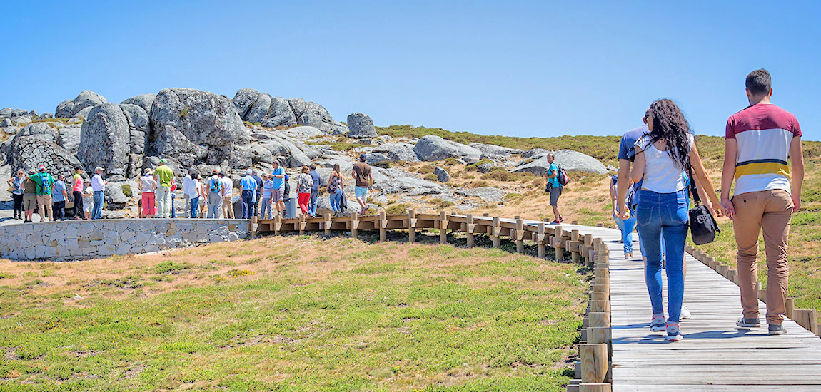
  3. Pedestrian Routes
    There is no better way to discover the most beautiful corners of the Arouca Geopark than on your own feet. The Arouca Geopark brings together a network of 14 short-route (PR) and one long-route (GR) walking trails that have, since 2001, played an important role in promoting the natural and cultural richness of this UNESCO World Territory. During 11 of the 14 walking routes, you can easily access 18 of the geosites in this territory, these being considered geotouristic walking routes;

  4. Paiva Walkways
    Since June 2015, the Paiva River has stopped being so mysterious and distant, only within the reach of fishermen and those who venture into the wild waters. The Paiva Walkways brought us closer to the shore, to the unique fauna and flora, to the geological outline that its route traces. Your steps, your footprint and your images help us to value and preserve the natural resources that develop here. With each trip along this route, we seek to educate about sustainable development, guiding the eye along the landscape, the shore, every detail that, until recently, was inaccessible;

  5. Water and Stone Route
    The discovery of the Magic Mountains® is made through a kind of metro line, with stops consisting of places to visit, in the immensity of the mountains, between the Douro and Vouga. This guiding line is A Rota da Água e da Pedra® (RAP), a tourism and nature route in which, from south to north, the lines of Vouga (V), Arestal (T), Arada (A), Freita (F), Caima (C), Paiva (P), Montemuro (M), Bestança (B) and Douro (D) follow each other.

    This route, across the 7 municipalities of the Magic Mountains (Arouca, Castelo de Paiva, Castro Daire, Cinfães, São Pedro do Sul, Sever do Vouga and Vale de Cambra), consists of 9 routes and 114 panels with 200 must-visit tourist attractions;

  6. Industrial Tourism
    Discovering Industrial Tourism is an initiative of Turismo de Portugal, made up of a set of activities that provide the discovery of industrial heritage and living industry, and that characterize and differentiate the territories of our country.

    Arouca Geopark is betting on a new tourist segment, both in terms of live industry and industrial heritage. Arouquense gastronomy takes the lead in this type of tourist offer, which will feature guided tours and presentation of the cooking processes.

These trails are excellent for those who want to explore the Arouca Geopark on foot, with different levels of difficulty, and are ideal for all types of adventurers. Furthermore, the routes provide an enriching experience in communion with nature and the region’s fascinating geology.

Arouca Geopark
© photo by Arouca Geopark

Gastronomy

Doces Conventuais de Arouca
© photo by DocesDeArouca.pt

In this chapter, in Arouca, one can start at the end due to the enormous notoriety of its conventual sweets. Inheritance from the times when nuns still inhabited the Monastery, you will not be able to resist to sweet chestnuts, nun bellies, almond cigars or tp sweet black pudding. The Arouquesa breed cows are raised free and graze in the mountains, which gives a unique flavor to their tender meat. Veel or the famous Alvarenga steaks are mandatory delicacies, as well as the equally delicious Gralheira lamb, in the wood oven. All accompanied with a good regional Verde Wine.

Rivers, Outdoor Activities and Adventure Sports

Rafting no Rio Paiva
© photo by Odisseias.com

Owner of an extremely generous geography, Arouca has a panoply of rivers with great characteristics for the practice of several adventure sports. The Paiva river, in its courses of white water, is an international destination for the practice of Rafting and Kayak, being this second modality, solo, practiced in the rivers Paivô and Frades. A more multifaceted modality, the Canyoning allows you to swim, jump, slide and rappel down rivers and its rough canyons and waterfalls, with 9 circuits in Arouca. Out of water, Mountain Biking and Climbing are the kings of the mountain.

🚌 How to get to Arouca: Transport and access

Arouca is well connected to several cities in the north of Portugal, and is easily reached by car. For those coming from Porto, the journey takes around 1 hour and 15 minutes via the A32, a comfortable and direct route. It is also possible to reach Arouca by public transport, with buses leaving from several cities in the region, including Porto. If you prefer, you can opt for a taxi or private transport service, especially if you are traveling in a group. For those who don’t have a car, there is also the option of taking a bus to neighboring cities and then taking a taxi to the center of Arouca.

For those coming from Lisbon, Arouca is about a 3-hour drive away. The best option is to take the A1 to Coimbra, and then take the A25 towards Viseu, following signs for Arouca.

🔆 One-day itinerary in Arouca: What to visit in 24 hours

If you only have 24 hours to explore Arouca, start the day with a mandatory visit to the Paiva Walkways and Ponte 516 Arouca Bridge, one of the largest suspension bridges in the world, which offers dizzying views over the Paiva river gorge. Enjoy the rest of the afternoon in Nature and visit some parts of the Arouca Geopark (part of the UNESCO network) and Serra da Freita. In the late afternoon, head to the picturesque Historic Center where you can still catch a glimpse of the Arouca Monastery, an important monument dating back to the 12th century. Arouca is famous for its traditional gastronomy, so end your visit with dinner in one of the many typical restaurants that serve the famous Posta Arouquesa.

Mapa Infográfico O que Fazer e Visitar em Arouca Monumentos Atrações Turísticas Passadiços do Paiva Geopark
© Cimo da Vinha 2025

cover photo © Câmara Municipal de Arouca

ABOUT THE AUTHOR

Cimo da Vinha is a Nature Tourism enterprise in Castelo de Paiva, between the Paiva and Douro rivers (on the border with Arouca). Its team is made up entirely of local workers with a deep knowledge of the regional geography and its traditions. This knowledge of the territory is one of our biggest differentiators. This understanding of the territory is at the service not only of our guests but also of this Blog.